The Lexicon of Restorative Agrisolar Design
A shared design language for agrisolar photovoltaic landscapes
Restorative Agrisolar Design
Working draft, circulated for comment. Some citations are not yet verified and are marked where they appear, and the evidence base says what is established, what is inferred, and what nobody has measured.
Solar and farming want the same flat, open, well-drained ground. An array can carry pollinator habitat or gravel, slow runoff or redirect it, shade stock, retire irrigation demand, or help sustain a farm. Those are design decisions.
Agrisolar names solar that occupies agricultural land, sits among it, or results in continued or new production, whether or not anything still grows beneath the panels. Agrivoltaics is the narrower case of crops or livestock inside the footprint itself. Direct crop production under or between panels is under two percent of built practice, and it takes a large share of the research attention (Stid et al. 2022; Macknick et al. 2022). A working vocabulary has to describe the other ninety-eight percent as precisely as it describes the exception. Where the boundary is drawn decides what counts. Most accounting stops at the fence line, the top of the modules, and a meter into the soil. This document draws it around the farm operation and the community hosting it, so a lease that keeps a farm solvent, the water leaving the field, and the habitat next door are all inside the frame.
Restorative agrisolar design holds that ecological, hydrological, and community function belong among a project’s objectives. This document gives that claim a vocabulary that can be tested on real ground.
How the language works
The document answers five questions in order, and a reader who only wants one of them can start there.
| The question | Where it is answered | |
|---|---|---|
| 1 | What can this project actually change? | Design Levers — six decisions, and nothing else |
| 2 | Who wants what from it, and who is going to lose? | Design Pressures — nine forces, with advocates |
| 3 | How much ground does it take? | The Scale Transect — a barn roof to ten thousand acres |
| 4 | What happens to the farming on that ground? | The Farming Axis — carried on, cut back, ended, or begun |
| 5 | What gets better, and who receives it? | Restoration Modes and Restorative Functions |
Almost every decision in a solar project belongs to one of six groups, and this document calls them the design levers: scale, siting, structure, management, ownership, and contracts. They are the spine of everything else here. The pressures push on them, and what comes out the far end is the three readings this document puts on a project: its scale, its position on the farming axis, and the restoration mode that carried the work — and, from those, the functions the ground ends up performing.
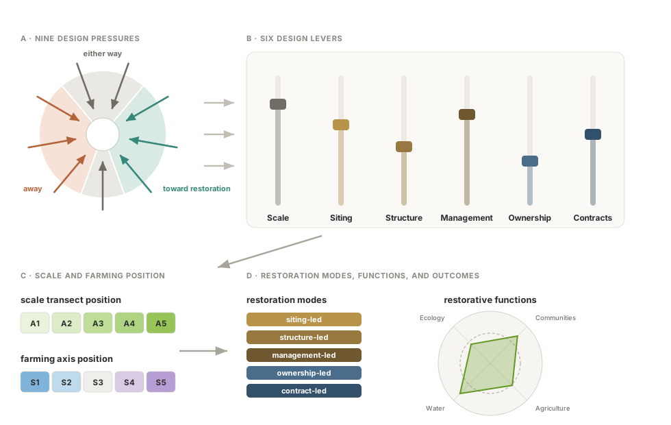
Three of the nine pressures push toward restoration, three push away, and the direction of the last three is settled by the site, the buyer, or the county (Figure 2.1). Each one pushes harder in some regions than in others, which is why a California project and an Iowa project set the same six levers differently. A setting of the levers that recurs on real ground is an archetype: an array sized to the milking parlor, or one standing on ground whose irrigation was retired.
Two things here carry enough structure to need a chapter of their own, and only one of them is a lever. Scale becomes the scale transect, five calibration points from the farmstead to the complex, because interconnection, decision-making, and ground management all move together along it. Scale itself produces no restoration mode, which is why it carries no color of its own; what it decides is how much room the other five levers have to work in. The other is not a lever but an outcome: siting, structure, and management jointly produce a position on the farming axis, which records what happened to agricultural production: where a farm still works the ground, the position turns on whether the use is the one it carried before or a lesser one, which is settled by what was built and what is grown; where farming has stopped, it turns on what the ground was beforehand, which is settled by where the array went. Ground that carried no farming before the array and carries some under it takes a position of its own, past the sharing end.
The aim is argued; the dimensions are left to the site. This document takes a position on what agrisolar is for, and refuses to fix a clearance height or a row spacing, because the same lever settings that restore ground in one region deplete it in another. Regionality is where that gets explicit.
Chapter contents
| Chapter | What it holds |
|---|---|
| Design Levers | the six decisions a project can actually make, three physical and two institutional, with scale setting the frame for all of them |
| Design Pressures | the nine forces arguing over how those decisions get made, where they collide, and how their weights shift by region |
| The Scale Transect | A1 to A5, farmstead to complex, and how much of every other lever survives at each size |
| The Farming Axis | S0 to S5, what happened to agricultural production on the ground the array took, and which positions each scale allows |
| Restoration Modes and Potential | which lever is made to carry the restorative work, how much each can still do at each size, why the community scale stands out, and the two different kinds of work called restoration |
| Restorative Functions | the four functions a design can be aimed at, the eight outcomes they carry, and which route each benefit travels to whoever receives it |
| Archetypal Forms | recurring settings of the levers that already exist on real ground, six worked through and seven sketched, from barnyard shelter to solar prairie strips |
| Terminology | every defined term, grouped by subject, with an A–Z index alongside |
| Evidence Base and Research Needs | how well each claim is evidenced, stated once rather than hedged everywhere, and the measurements that would settle what is still inferred |
| Sources | every claim traced, split into what has been verified and what still needs tracing |
Joining in
Corrections, counterexamples, and proposed terms are welcome as issues or pull requests on GitHub. Especially useful: an archetype that recurs in your region and is missing here, a term that lands badly with the people who have to use it, or a citation you can trace further than we have.