3 The Scale Transect
Somebody chose five megawatts rather than eighty. It was decided early, on grounds of interconnection and capital, probably before anyone walked the ground, and it set the limits of every choice the design had left: how much ground there was to choose among, what hardware was affordable, who would manage the vegetation, and who would end up owning the asset. That decision is scale, the first of the six design levers — how much ground the project takes, and the one most often mistaken for a fact about a site rather than something a person settled.
Scale earns a chapter because its consequences travel together. Interconnection posture, the decision unit, the permitting path, ground-layer management, and siting latitude all shift as projects get bigger, and they shift closely enough that naming a position on the gradient tells you many things at once. That gradient is the scale transect, and A0 through A5 are named points along it rather than a separate kind of thing.
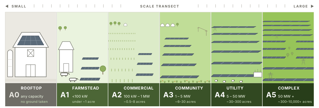
3.1 Five zones on one gradient
A 30-kilowatt barn array and a 300-megawatt complex are both solar on farmland, but their decision-makers, finance, grid connection, ground management, and possible land functions differ. Scale is therefore a transect: a gradient of attributes that change together, rather than a set of capacity bins. Capacity is a useful hint, not the definition. The zones below are calibration points on that gradient in the sense the rural-to-urban transect uses them, which is to say named places to stand rather than boxes with walls. Pressures shift continuously along it, a 4 MW project and a 6 MW project differ by less than their labels suggest, and a project near a boundary should be read as being near a boundary. What moves together is:
- How it connects to the grid: behind the meter → distribution → transmission
- Who decides: one landowner → several parties at a table → a utility with a place in the interconnection queue
- What it takes to permit: allowed by right → site plan review → full environmental review
- Who manages the ground: existing farm labor → purpose-built for the site → an outside contractor
- Where the money comes from: the owner’s pocket → tax equity and a power contract → project finance
- Who has to be talked to: the neighbors → the township → a regional process
- Siting latitude: opportunistic → strategic → decided by what land could be assembled near a substation
Physical effects change with geometry and scale as well. Soil cooling and moisture retention are more consistent than air-temperature effects, which vary by site (Zhang et al. 2025).
| Zone | Indicative capacity | Indicative footprint | Interconnection | Decision unit | Ground-layer management |
|---|---|---|---|---|---|
| A1 — Farmstead | <100 kW | under ~1 acre | Behind-the-meter, net metered | Single owner-operator | Existing farm labor and equipment |
| A2 — Commercial | 100 kW–1 MW | ~0.5–8 acres | Behind-meter to distribution | Landowner, possibly one lease counterparty | Existing equipment, modest adaptation |
| A3 — Community | 1–5 MW | ~6–30 acres | Distribution; community solar, mid-market PPA | Multi-party: landowner, developer, offtaker, tax equity | Purpose-built: dedicated mowing, contract grazing, seeded establishment |
| A4 — Utility | 5–50 MW | ~30–300 acres | Distribution to sub-transmission; queue position matters | Developer-led, institutional capital | Contract enterprise: commercial graziers, habitat contracts |
| A5 — Complex | 50 MW+ | ~300 acres to 10,000+ | Transmission; merchant or utility PPA | Utility/IPP, multi-jurisdiction | Contract enterprise at ranch scale; multi-site rotation logistics |
Capacity is how a project is filed; acreage is how landholders and communities experience it. Trackers and agrivoltaic clearance use more land per megawatt than dense arrays, so acreage is the better guide when the two disagree (Gallaher et al. 2026; Sturchio et al. 2025).
The conversion behind the acreage column, and its shelf life. The footprints above assume 5.5 acres per MW-AC for fixed tilt and 6.3 for single-axis tracking, which is what Berkeley Lab measures for operating systems under 20 MW; counting setbacks, access, and interconnection the total site runs nearer 6 to 8. Wide-row agrivoltaic layouts roughly double it. These are 2020s numbers and they have been falling for a decade as modules improve, so treat the acres as a conversion to redo rather than a constant, and expect a later edition of this table to show smaller footprints for the same megawatts. The fall is bounded, though. A commercial silicon module converts a little over a fifth of the light reaching it against a single-junction thermodynamic ceiling near a third, so there is roughly a third of improvement left in that architecture before physics closes it. Tandem cells can pass that ceiling, which makes the floor soft rather than fixed, but not open-ended. Land intensity will improve and then stop improving.
Building-mounted arrays are A0 — Rooftop: no ground to choose, manage, share, or spare, which puts them at the origin of the gradient rather than on it. A5 has no ceiling; its common condition is placement fixed by land assembly and restoration carried by management (§5.2).
A4 spans a wide range and probably contains a break of its own, near 20 to 25 MW. That is not a land threshold but a jurisdictional one: it is roughly where several states move siting authority from local boards to a state office, New York’s being the clearest case. Below it a township still decides, and a design argument can be made to people who live there. Above it the venue changes and so does the audience. The lexicon has not split A4 on that line yet, because unlike the 5 MW boundary it rests on one attribute rather than several converging ones, but a reader working between 20 and 25 MW should expect the project to behave like the zone above rather than the zone below.
The bands in the table fit the US Midwest and should be redrawn elsewhere. Not every zone exists in every region.
A worked example: grazing across the transect. Sheep grazing keeps the same name from the farmstead to the complex, and stops being the same job about twice along the way. Following one practice across the zones shows what the transect is actually measuring, because nothing about the animal changes and almost everything about the arrangement does.
The choice of animal is made before the scale question arises. Sheep fit standard racking, goats climb it and chew wiring, and cattle and horses need more clearance than a standard array leaves them (Merheb et al. 2025), so in practice it is sheep or it is mowing.
| Zone | Who grazes | Typical figures | The design problem |
|---|---|---|---|
| A1–A2 | the farm’s own flock | ~3 ewes/acre in New York and Michigan experience (Hartman 2026); 4–20 sheep/acre in rotational trials at Cornell | matching stocking to the forage and the weather in front of you, rather than to a published rate |
| A3 | a contracted grazier | ~$300–500/acre/yr for vegetation management | building a site that works for someone who does not live on it and visits on a schedule |
| A4–A5 | a logistics enterprise | mowing medians across 54 utility-scale sites: $113/acre/yr at sheep-grazed sites, $121 at native-vegetation, $203 at turfgrass; herbicide $293 on gravel (McCall et al. 2023) | water, gates, hauling, and rotating a flock between parcels that do not touch each other |
Two terms come apart here and are worth keeping apart. Stocking density is how many animals are on the ground at one moment, and carrying capacity is what the forage will feed across a season. Growth, utilization, and weather all move one without moving the other, which is why the A1–A2 figures above are a range rather than a rate.
Establishment is the cost that catches people out. Measured per activity, native and pollinator-friendly covers run below turfgrass, and yet total vegetation O&M came out slightly higher, because the first three to five years take more separate passes across the site (McCall et al. 2023). Restorative ground cover is expensive to establish and competitive once established, so anyone arguing for it on cost savings alone should expect to meet an operator holding the establishment invoices.
So “solar grazing” on its own names three different practices, and which one a person means is usually settled by the size of the project they last worked on.
3.2 Scale modulates the other five levers
Of the six design levers, scale is the only one that does no restorative work of its own. Choosing five megawatts over eighty plants nothing and obliges nobody. What it does is decide which of the other five a designer still has a hand on by the time the layout is drawn. Scale is the master lever because it is spent before the others are picked up, and little later in a project wins back what it closed.
Siting latitude shows the mechanism plainly, because the decision is physical and somebody has to point at a piece of ground. What changes with scale is whose arm does the pointing.
| Zone | What decides where it goes | Who actually chooses |
|---|---|---|
| A1 | The yard, the herd, and the existing service drop | The operator, with almost no ground to choose among |
| A2 | Spare corners, awkward field ends, ground already sitting idle | The operator |
| A3 | Consistently low-yielding ground, where the water runs, buffer geometry | Developer and landowner, deliberately, together |
| A4–A5 | Contiguous acreage near a substation and a place in the queue, nudged at the edges by prime-farmland rules, likely opposition, and which communities benefit | The land market and the grid, filtered through policy veto points |
Read the two columns against each other. At the farmstead the operator holds the whole decision and has almost nothing to decide, since one spot in the yard may be the only spot. At A3 a developer and a landowner walk the field together and can put the array on the wet depression or the corner that never yields. By A4 the middle column has filled with things nobody at the table controls, and the right column stops naming a person. The developer still signs the lease. The ground was chosen by whatever acreage could be assembled near a live queue position, and everything else in that row only trims the list.
The other levers travel the same way, less visibly. Racking at A1 is whatever a local installer can source for one particular yard, and at A5 it is a catalog item bought by the megawatt, so the structural decision passes from a person standing in the yard to a procurement schedule. Ownership moves furthest: at the farmstead the party deciding and the party living with the decision are one person, and by A5 they are an investor, a landowner, and a township. Every lever survives the trip. None stays in the same hands.
What those levers can still deliver once scale has decided who holds them is a separate question, and §5 takes it up. The point here is that the capacity number on a term sheet has already answered part of it: a project filed at 80 MW gave away its choice of ground before the first site visit, and one filed at 3 MW kept that choice and will pay a premium per watt for it.