8 Terminology
Definitions are grouped by subject, in the order the chapters introduce them, and each links to its fuller treatment. The alphabetical index provides the same terms A–Z.
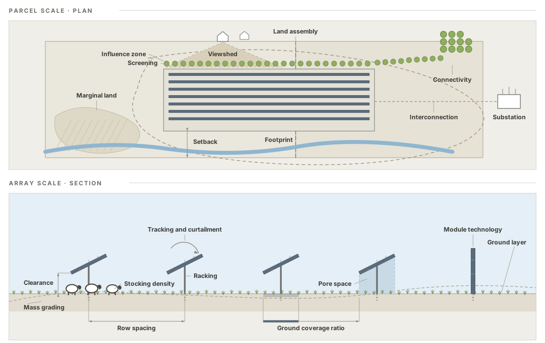
In plan the terms mark out ground: what the array occupies, what is held open at its edge, how far its effects carry past the fence, and the line to the substation that settled how big the project could be. In section they mark out geometry, which decides what can grow and work underneath. The dashed line beneath the rows is the surface that was there before the site was graded, and the fifth row stands vertical, which is one of the module technologies rather than a drawing error. Terms defined below that name an idea rather than a place, among them agrisolar, ecovoltaics, dual use, and the land equivalent ratio, have nothing in the drawing to point at.
8.1 Design levers and pressures
Developed in §1, Design Levers and §2, Design Pressures.
Design pressures
The competing forces every site must resolve. Unlike axes they have direction, they conflict, and real parties advocate for them. Nine are named. See §2.1.
Design tension
What a resolution of the design pressures leaves unresolved. It is never nil, because the nine cannot all be satisfied at once and the project gets built regardless, so the question is how much remains and who is carrying it. Low tension is not the same as agreement: a design can be quiet because the pressures accommodated each other, or quiet because a party with a real claim stopped pressing it. The settings that leave least are the ones that recur, which is what an archetype is. See §2.2.
Coined here, and it collides. An engineer reading a racking specification will meet design tension as the tensile load a member is sized to carry. Nothing crosses over but the word: this one is a property of an argument, not of steel.
Energy yield
Pressure: maximize energy per unit land. Pushes toward dense row spacing, optimal tilt and tracking, low clearance, whole-field coverage. See §2.1.
Cost and financing
Pressure: minimize what the project costs to build and what it costs to finance. The first pushes toward standard racking, low clearance, minimal ground preparation, and conventional geometry. The second is a different force with the same sign: transaction costs do not scale down, so a 2 MW project carries much the same paperwork as a 200 MW one, and a small offtaker is likelier to lack a credit rating. Held under one name because a design has to clear both, and a project that pencils on capex can still fail to raise the money. It is why the zone with the most design freedom has the least access to capital (§5.3). See §2.1.
Operations and maintenance
Pressure: minimize management burden across a 25–40 year asset life. Pushes toward uniform, mowable or gravel ground cover, and can oppose cost and financing, since native seeding raises capex and lowers long-run opex. See §2.1.
Agricultural production
Pressure: keep working land working. Pushes toward high clearance, equipment access, production ground layers, farmer contracts. See §2.1.
Restorative goals
Pressure: make ecological, hydrological, and economic resilience a design objective co-equal with generation. The pressure this document exists to advance, and still a force among forces. See §2.1.
Community acceptance and benefit
Pressure: secure and sustain community acceptance and community benefit. Acceptance is about process: who was asked, when, whether the answer could still change the design, and whether the people who live with the result trust how it was reached. Benefit is about receipts: who ends up with money, opportunity, resilience, or protection from a harm they would otherwise carry. Held under one name because a design has to advance both, and worth holding apart because they come apart in both directions — a project can pay a community it never consulted, and consult one thoroughly while leaving it nothing. Neither substitutes for the other, and paying first is not consent (Crawford et al. 2022; Ryder et al. 2023). See §2.1.
Grid and market demands
Pressure: satisfy whoever is buying the power, the attributes, or the tax position. The channel through which outside parties push their requirements onto a design. See §2.1.
Policy and permission
Pressure: satisfy the rules that decide whether the project happens at all, and the subsidies that decide what pays. Permitting path and zoning, prime-farmland and setback rules, state programs, and federal incentives. It is the one pressure whose direction is set by the jurisdiction rather than by the site or the buyer, which is why it belongs to regionality as much as to the pressure set itself. See §2.1.
End-of-life responsibility
Pressure: minimize the residual footprint left after a 25–40 year asset life and preserve the option to return the ground to its prior use. For the end-of-life vocabulary itself, see Decommissioning / Repowering / Reversibility. See §2.1.
Design levers
The six kinds of decision a project can actually make, and the only things anyone can change: scale, how much ground it takes; siting, which ground; structure, what gets built; management, what grows and how the place is run; ownership, who holds the asset; and contracts, what the parties signed. Scale sets the frame; the three below it act on ground and are limited by how much of it there is; the last two are institutional and are not. Which lever carried the restorative work is the restoration mode. See the Design Levers chapter, and §5.2 for the levers read against the transect.
Borrowed, and turned. The six levers are the lexicon’s own; the reason for sorting them this way is borrowed twice over from architecture. Brand (1994), after Frank Duffy, reads a building as layers of differing longevity and holds that a design works when the fast layers can move without tearing the slow ones, which is why management sits apart from structure here rather than inside it. Habraken (2002) adds that every level has a decision-maker of its own, which is the ownership lever stated as design theory. Neither author was writing about land, and neither has anything corresponding to siting.
8.2 Regionality
Developed in §2.3, Regionality.
Regionality
The claim that the design pressures resolve differently in different places, because the factors that weight them vary across space. The vocabulary is constant everywhere; which positions are available, which functions are reachable, and how hard each pressure pushes are not. See Regionality.
Regional factors
The six spatial factors the lexicon reads a region by: the resource (sun and cloud, including diffuse fraction), the grid operator (queue, curtailment, and the state programs that decide whether A3 exists), aridity (which flips the sign of the shade effect), latitude (which sets tilt, row spacing, and the inter-row light budget), the cropping system (which decides whether sharing is conceivable), and irrigation (which makes retirement at scale available or unavailable). See §2.3.1.
Regional calibration
A restatement of the lexicon’s indicative values for a particular region: capacity bands, absent zones, the binding constraint, the positions realistically open. The US calibration in §2.3.2 is one such, not the general case; calibrations from other regions are additions rather than corrections. See §2.3.2.
Design import
The characteristic regional failure: carrying a resolution from the region where it was demonstrated into one whose factors differ, as when a shade benefit shown in the Southwest is assumed in the Midwest, a habitat specification calibrated on one establishment cost written into a contract for another. Grid and market demands is the usual vehicle, since a buyer’s criterion travels further and faster than the evidence behind it. See §2.3.3.
Diffuse fraction
The share of irradiance arriving as diffuse rather than direct-beam light. Cloud collapses the beam component while diffuse holds up, so humid and cloudy regions run a higher diffuse fraction of light, which is non-directional, reaches under and between panels, and is most of what a ground layer lives on. It also weakens the case for tracking. See §2.3.1.
8.3 Scale
Developed in §3, The Scale Transect.
Scale Transect
A single gradient from farmstead (A1) to complex (A5) that most other terms are read against, defined by covarying attribute bundles rather than capacity thresholds. The zones are named for the size of the development rather than for the land unit it sits on, so that no zone name is outgrown by the array it describes. See The Scale Transect.
Borrowed, and turned. The device is the rural-to-urban Transect of the New Urbanism (Duany Plater-Zyberk & Company 2014), which is where the lexicon takes its name and its method of calibration points. One thing changes in the borrowing, and it matters: that transect is a gradient across the ground, a line you could walk from wilderness to urban core, while this one is a gradient of project size. Two A2 projects can sit a mile apart, and an A5 can surround an A1.
A0 — Rooftop
Arrays mounted on buildings, and by extension on carports and canopies, which take no ground at all: no siting latitude to spend, no ground layer to design, and no farming axis position to hold. It sits at the transect’s origin rather than on it. See §3.1.
A1 — Farmstead
<100 kW, under about an acre; behind-the-meter, single owner-operator, existing farm labor and equipment. See §3.1.
A2 — Commercial
100 kW–1 MW, roughly 0.5–8 acres; behind-meter to distribution, landowner with possibly one lease counterparty. See §3.1.
A3 — Community
1–5 MW, roughly 6–30 acres of array; distribution, community solar or mid-market PPA, multi-party, purpose-built ground management. Big enough that management arrives and small enough to site deliberately, which makes it the only zone carrying both restorative instruments at once and the widest part of the feasible wedge. The zone takes its name from the trade’s own community-scale solar, a phrase carrying several senses at once: sized to a community’s load, sited where communities already are, structured so benefit reaches a community, and building community resilience through a distributed fleet. That the name is also the name of an outcomes footprint domain is not a collision but the argument: A3 is the zone where community outcomes are most likely to land. See §3.1 and §5.3.
A4 — Utility
5–50 MW, roughly 30–300 acres; developer-led institutional capital, contract-enterprise ground management. The zone where a project is first built to serve the grid rather than a load on the site, which is what utility-scale names in the trade. The widest band on the transect, and it probably contains a jurisdictional break near 20–25 MW, the capacity at which several states move siting from local boards to a state office. Not split yet (§3.1). See §3.1.
A5 — Complex
50 MW+, from roughly 300 acres to 10,000 and beyond; transmission, utility or IPP across jurisdictions, contract enterprise at ranch scale. Open-ended by design, and named for what it becomes at that size: not one array but several run as one, often across parcels that do not touch. See §3.1.
Siting latitude
The designer’s freedom over where the array goes. What governs it migrates from opportunistic placement to land assembly and grid topology up the transect, and it peaks at A2–A3, bounded by the parcel at A1 and by the land market at A5. The constraint that makes the feasible region a wedge. See the five modes for the modes against the levers, and §5.2 for which one dominates at each zone.
Stocking density
Instantaneous animals per unit area at a moment; diverges from carrying capacity with forage growth, utilization, and climate. A grazing design variable to calibrate, not a fixed rate. See §3.1.
Carrying capacity
The season-long forage the land sustains over time, distinct from instantaneous stocking density. See §3.1.
Borrowed, and worth placing. This is range science’s carrying capacity: a stocking target set by the forage a management unit grew this season and by what the manager is trying to achieve with it, so it moves from year to year and can be argued about. It is not population ecology’s K, the level a population settles at when nobody is managing it, which is what a reader coming to the same site from a habitat plan will assume. Both senses can turn up in one project file, so a number is worth labeling.
Contract grazing
Grazing delivered as a contracted vegetation-management service by a party who does not live on site; appears at A3 and scales up into a logistics enterprise. See §3.1.
8.4 The farming axis
Developed in §4, The Farming Axis.
Farming Axis
The second, largely scale-independent dimension: whether the array shares land with agricultural production (land sharing), spares land by taking ground out of it (land sparing), or neither. The pair is borrowed from conservation ecology (Green et al. 2005; Phalan et al. 2011); the short form sharing–sparing is used for the axis, the full form in prose. Five positions, centered on S3, with a sixth past the sharing end for ground the array brings into agriculture rather than takes out of it. The names run on two stems, because the axis changes character at its middle: where farming continues the position is named for the agriculture left on the ground, and where it has stopped the position is named for the ground the array was sited on. See The Farming Axis.
Borrowed, and turned. In conservation ecology the sharing–sparing question asks how intensively to farm a landscape so that the remainder can be left to nature, argued at landscape scale against a fixed food target, with biodiversity the outcome that settles which way to go (Green et al. 2005; Phalan et al. 2011). Three things change here. The thing being placed is a power plant rather than a farming regime, the unit is one project on one parcel, and the axis records what happened to production rather than scoring an outcome. That is why it has a middle: S3 is neither sharing nor sparing, and the ecology debate has no position for it.
S0 — Created agriculture
A farm takes something off ground that carried no agricultural use before the array: a capped landfill or a decommissioned industrial parcel grazed under panels, previously developed urban and peri-urban ground put back to stock. It is the only position recording a use that began rather than one kept, stepped down, or lost, which puts it past the sharing end and on the starting a benefit side of the split rather than the harm-reduction side the other five share. Uncommon, and no claim about quality. See §4.1.
S1 — Primary agriculture
The agricultural use continues essentially as it was, with the array added over or between it: a vineyard still a vineyard, a pasture still a pasture, a row crop still cropped between the rows. This is agrivoltaics in the strict sense, and the test is comparison with what the ground did before rather than with what the array needs. See §4.1.
S2 — Secondary agriculture
The ground still carries an agricultural use, but a lesser one than it carried before: cropland grazed instead of cropped, or a sown layer worked for forage, hay, or hives. Agriculture continues; its value is stepped down. Available at every scale, and with S1 and S3 the spine of the feasible wedge, since grazing splits across S1 and S2 by what the ground carried before. See §4.1.
S3 — Ordinary-land siting
Neither sharing nor sparing: the array takes ordinary productive ground outright and the revenue sustains the farm enterprise holding it, so the restoration is socioeconomic before it is biophysical. Where the rent reaches a non-farming owner and the operation ends, the site is bare conversion instead. The center of the axis, and where most projects sit. See §4.1.
S4 — Low-productivity siting
The array takes ground that was already idle, marginal, or chronically low-yielding, so nothing in production was displaced to build it. The name records the ground taken, which can be checked on site. The benefit — that productive land elsewhere went unbuilt — is a landscape claim and is carried by the definition rather than by the name, because it cannot be read at the site. See §4.1.
S5 — Impaired-land siting
The array takes ground that carried a measurable off-site burden such as high runoff, nutrient or pesticide export, or irrigation draw beyond the aquifer’s budget, or ground positioned where such a burden can be intercepted. Unlike S4, the act works on the ground taken itself: production ends and the burden ends with it. See §4.1.
Bare conversion
Ordinary ground converted with the farm operation ended: the same ground fact as S3 without the restorative one. The non-restorative baseline the axis is read against, not a position on it. See §4.1.
Feasible wedge
The feasible region across scale and sharing, and it is not symmetric. The sharing edge runs flat across the whole transect, because farming carries on under panels at every size, from the operator’s own yard at A1 to a contracted flock on former pasture at A5. It is the sparing edge that opens with scale, from almost nothing at A1 to the full range by A3. Only S4 thins toward A5, because land assembly cannot collect scattered remnants. Each thinned corner has a documented exception. See §4.2.
Coined here, and it collides. A reader from energy or climate work will hear Pacala and Socolow’s stabilization wedges (Pacala and Socolow 2004), where a wedge is a slice of avoided emissions widening to a gigaton of carbon a year and the point of the picture is that the slices add up. Nothing carries across but the shape word. This wedge is a region on the scale-by-sharing plane showing which positions are actually available, and it narrows toward both of its ends.
8.5 Restoration modes
Developed in §5, Restoration Modes and Potential.
Restoration mode
Which design lever a design commits to carry the restorative work: the choice of ground, the array’s geometry, how the array is run, who holds the asset, or what the parties signed. Each mode names a lever, so there are five modes for six levers. Scale has none, because deciding how big to build is not itself a way of doing restorative work, only what settles which ways stay available. The first three are done physically and shift along the transect as siting latitude rises and falls (§5.2). The last two are institutional and trade against each other: ownership-led is free at the farmstead and unavailable at utility scale, and contract-led runs the opposite way. Five modes:
- Siting-led — the restorative work is done by the choice of ground; requires the A2–A3 latitude to choose it.
- Structure-led — array geometry does the work: clearance, row spacing, module transmissivity.
- Management-led — placement is a given, and the ground cover, grazing regime, and operational schedule carry everything. The dominant mode at A4–A5.
- Ownership-led — the work is done by who holds the asset, and no agreement is needed because the parties were never opposed. Strongest at A1–A2, where the operator owns both the array and what stands under it, and effectively unavailable once the owner is absentee.
- Contract-led — the work is done in the lease, the ordinance, or the benefit agreement rather than anywhere on the site. The mode the community and economic function runs on, and the one that decides whether the tenant is still farming in year twenty (§6.4).
Borrowed, and turned. The phrase is already in use in ecological restoration and land reclamation, where a restoration mode is a package of restoration techniques matched to a site’s degree of degradation (Zha et al. 2025). Here it names which lever carries the work instead, which is why two of the five are institutional rather than anything done to the ground. The nearest existing framework for sorting interventions by the instrument that delivers them is the IUCN and CMP conservation actions classification (Salafsky et al. 2008), whose top categories line up with four of these five and have no equivalent of structure-led. Two collisions are worth naming for this audience. In the solar trade site restoration is a decommissioning obligation, what a lease owes when it ends, so a mode here is a choice made at design rather than a phase at the end of life. And ownership-led means the restorative work is carried by how the asset is held, not that the owner is running the project.
See the five modes for the modes against the levers, and §5.2 for which one dominates at each zone.
8.6 Restorative functions
Developed in §6, Restorative Functions.
Restorative function
A restorative capacity a project can be designed to deliver, obtainable to varying degrees from many structural positions at once, the columns laid over the archetypes as rows (§6). Two are biophysical, one agricultural, and one socioeconomic. See Restorative Functions.
Not ecosystem services renamed. An ecologist will read the four as the Millennium Assessment’s categories in new clothes, and the overlap is real, but the sorting principle is different: services are grouped by what an ecosystem supplies, and these by what a design can be built to deliver. One of the four is socioeconomic, food production sits on the farming axis instead of among the functions, and a function here is an objective a project is held to rather than an account of what a place already does. Service classifications are plural and built for the purpose at hand (Costanza 2008); this is one more of them.
Hydrologic function
Water quantity and quality as design objectives. On quantity: infiltration and recharge raised, soil moisture buffered, and at scale consumptive use retired from a basin’s budget. On quality, two routes needing opposite ground: avoided loading, siting on the ground that is doing the leaching, which the water-quality literature calls a critical source area, so the fertilizer and pesticide programs stop with the cropping, and interception, siting on the flow path below it so runoff gives up its nutrients and sediment before reaching a channel. See §6.1.
Ecological function
What can live on the ground and what can move through it. Habitat is built from the ground layer up, through floral resources, nesting substrate, and vegetation structure, with mowing and grazing timing as decisive as the seed mix; connectivity is the other half. Reachable across S1–S5, which is why it is a function and not a position: a grazed array on former pasture is S1 and can still carry a pollinator understory. See §6.2.
Connectivity
Whether organisms can move into, through, and out of a site, as against whether the site can feed them once they arrive. It is designed at four scales at once: inside the array by fencing, roads, and mown strips; at the edge by whether the planting meets an existing corridor; across a landscape by the choice between a few large arrays and many small ones; and at regional range by whether a fleet of sites falls within dispersal distance of one another. Connectivity is a property of the arrangement rather than of any one patch, and the scale on which it matters is set by the disperser, so a connectivity claim means little until it names the taxon. See §6.2.
Borrowed unchanged, and it collides. Landscape ecology’s term, meaning the degree to which a landscape helps or hinders movement among resource patches, defined by the organism doing the moving rather than by the map (Taylor et al. 1993). The lexicon takes that sense whole, including the demand that a claim name its species. What it declines is the structural reading in which connectivity is adjacency measured off a drawing, because a hedgerow can run unbroken on the plan and stop at a stock fence. On the electrical side of the same project the word means the connection to the grid, which is interconnection here.
Agriculture and soils function
What the array does for farming, on its own ground and on the fields around it: pollination and pest regulation carried by the ground layer beyond the fence, forage and stock shelter under the panels, and the lease revenue that keeps the operation running. Not the farming axis restated, which records whether production continues in the footprint rather than what the project gives farming. Its benefit delivery splits: the soil half stays in place, while the service to farming travels along living things, which makes that half the most dependent on what surrounds the site. See §6.3.
Community & economic function
The one socioeconomic function: the durable local income, the livability, and the question of whether the burdens and the benefits land on the same people, the outcomes footprint’s Communities domain read as an outcome, and distinct from the social-license pressure and community-benefit lever that aim at it. Only legible once the recipients are named separately. See §6.4.
Benefit delivery
How a function’s benefit reaches whoever receives it. The useful question is not how far it goes but which route it takes, since nearly every function reaches from the panel to the region along some path. Three routes. In place, where provider and beneficiary are the same ground. Along a connection, where the benefit travels a network: water carries runoff, sediment, and recharge downslope; living things carry pollination, pest regulation, and dispersal; institutions carry lease, tax, and subscription along tenure, contract, and jurisdiction. And by preservation, where nothing moves and the benefit is ground elsewhere that stayed as it was. The route decides who can verify a claim and who captures it. See §6.5.
Prior names. The distinction is borrowed, not coined. Hernandez et al. (2019) call an outcome that overlaps the generation site sympatric and one spatially separated from it disjunct, and assign each a serviceshed, the largest ecological scale at which it contributes goods and services. This lexicon splits the disjunct side into bands and adds delivery by preservation, which a service-based scheme cannot express.
Delivery by preservation
The mode in which a benefit consists of ground nearby remaining as it was. It is what land sparing delivers. It is proximate, because a developer assembling acreage near a substation chooses among parcels within a fairly narrow radius, so the ground spared is realistically ground in the same county. What it is not is observed: the claim rests on a counterfactual, and it is tested against the local land market and the sites genuinely in play rather than against an unbounded alternative. See §6.5.
Co-benefit
The field’s usual word for what this lexicon calls a restorative function. Recorded here because it is what practitioners will say, and used here only to describe how others frame the same ground. The term carries acknowledged definitional ambivalence, and its grammar demotes what it names, since a co-benefit arrives alongside the real objective (Mayrhofer and Gupta 2016). This document argues these capacities are objectives, so it does not adopt the word. Cf. techno-ecological synergy, the literature’s own attempt at a framing that does not subordinate them (Hernandez et al. 2019).
outcomes footprint
A whole-project reading across four domains, Communities, Agriculture, Water, and Ecology, each running from causing harm at the center, through avoiding harm, out to promoting benefit at the rim, so a larger shape is a better project (§5.4). Evaluative by design, but the ring where harm ends is a zero point rather than a pass mark. See Restorative Functions.
8.7 Archetypal forms
Developed in §7, Archetypal Forms.
Archetype
A recurring way the design pressures have been resolved at a particular scale zone and sharing position, carrying particular functions. Used in its plain sense, meaning a characteristic, transformable pattern rather than an exhaustive set. See Archetypes.
Plain sense, deliberately. Sustainability research runs a formal method under this word, archetype analysis, which sorts many cases into recurrent configurations of causal factors and tests the groupings against data (Eisenack et al. 2021). These archetypes are not that. They were assembled from practice rather than derived from a sample, they are not claimed to be exhaustive, and a real project can sit between two of them. The entry says “plain sense” to keep the stronger, methodological claim from being read into the word.
Overhead and interspace systems
The engineering standards’ hardware typology (DIN SPEC 91434; the NREL / InSPIRE configuration taxonomy): overhead systems mount modules above the working surface, interspace systems mount them low with the crop or cover between the rows. It classifies the structure, where an archetype classifies the resolution of pressures. See Archetypes.
8.8 Field terms and metrics
The vocabulary the lexicon adopts from the wider field and pins down for use here.
Agroenergy
Energy infrastructure that occupies or interacts with agricultural land functioning and operation, whether or not the interaction was intended. The broadest umbrella in this lexicon, non-solar-specific, and carries no requirement of design intent or outcome.
Term collision, flagged deliberately. Elsewhere “agroenergy” (and agro-energy) most often means agriculture-derived bioenergy: energy crops, crop residue, biogas, and biomass, meaning farmland as a fuel source. This lexicon repurposes the word for the converse: energy infrastructure placed on and integrated with agricultural land. The reuse is intentional but worth naming, so a reader arriving from the bioenergy literature is not misled. The infrastructure sense is live in the peer-reviewed literature: Stid et al. (2025) define agrisolar as the integration and co-management of solar photovoltaics, agriculture and ecosystem services within agroenergy landscapes.
Agrisolar
They key tenet of this lexicon, agroenergy specific to solar photovoltaics (PV): Solar PV that occupies or interacts with agricultural land functioning and operation. A neutral umbrella across the whole farming axis (S1–S5), intent- and outcome-agnostic like agroenergy and including any subsequent form of agricultural co-location.
Agrisolar potential can be technically defined from siting and management alone, as one or more of: * occupies: an array whose footprint was predominantly agricultural land before installation * adjacentTo: an array sitting substantially within or adjacent to neighboring land that is currently agricultural * managed: an array containing land inside the footprint that is under active agricultural management
An array meeting none, or that cannot be evaluated, is noCurrent. These record potential, not practice: attributing practice needs an array’s direct contribution to a farm, which siting and management do not resolve alone.
Syn.: multi-use solar (narrower: excludes S3–S5 without an ecological ground layer).
Source: Stid et al. (2025) — Sources SolarPower Europe (ADD CITE).
Agrivoltaics
Crop or livestock production within the array footprint (S1–S2). Crop response to shade is climate- and crop-dependent; a synthesis of 367 paired observations found yield response turning positive only in hotter conditions (Merheb et al. 2025).
The idea is older than the word. Goetzberger and Zastrow (1982) proposed running solar conversion and plant cultivation on one field and worked the geometry out, collectors about two meters up and rows spaced at roughly three times their height, which left about two-thirds of open-field radiation on the ground. That was decades before anyone built one at scale. The word itself arrived with Dupraz et al. (2011), whose modeling of crops under partial shade also brought the land equivalent ratio into the field. Neither the term nor the metric belongs to this lexicon.
Syn.: agrophotovoltaics (German); photovoltaic agriculture (Chinese); solar sharing (Japanese); agri-PV; PV agriculutre; aglectric.
Source: AFT Policy Reccommendations; SB 2931; NLR
Rangevoltaics
Grazing under and between panels. Its position turns on what the ground carried before: a flock on land that was already pasture is S1, and the same flock on former cropland is S2. The everyday name is solar grazing; the literature also uses rangevoltaics (Merheb et al. 2025). Species and clearance must be matched to the racking, which in practice means sheep (§5.2). Shade is also a benefit that can be a requirement: Humane Farm Animal Care certification mandates shade where temperatures run consistently above 22 °C, which makes an array a compliance instrument as well as a pasture.
Syn.: solar grazing; cattelvoltaics.
Ecovoltaics
Solar development that co-prioritizes ecosystem function with generation through siting, layout, ground-layer design, operations, and a viable business model (Sturchio and Knapp 2023; Tölgyesi et al. 2023). This lexicon treats its ecological ground layer as a restorative function, not an axis position. The framework favors repair of disturbed ground over conversion of intact native ecosystems (Sturchio et al. 2025).
The definitional dispute. AFT advances a production-based definition of dual use; critics argue it excludes ecosystem benefits and imposes a one-size-fits-all instrument on farmland protection. Both terms are defined precisely above, and both map to positions on the farming axis, which locates the disagreement where it belongs, as a genuine conflict between agricultural production and restorative goals (§2.2) rather than as a misuse of words. This document describes that dispute; it does not adjudicate it.
Syn.: nature positive renewables.
Dual Use
A production-based term: co-location that keeps active agricultural production within the array footprint across the project’s life, which is American Farmland Trust’s criterion. Structurally a mandate for S1–S2. Distinct from ecovoltaics, whose ecological ground layer is a function rather than production; the two are the poles of the definitional dispute the lexicon holds open rather than adjudicates (§4.2).
Restorative
The frame of this entire lexicon rather than a dimension within it. Applied when ecological, hydrological, or economic ground-layer function is a design objective co-equal with generation, not an incidental byproduct. US arrays are designed primarily to maximize output and minimize cost; co-benefits arrive incidentally or through a patchwork of state and local policy (Hernandez et al. 2014; McCall et al. 2023). Restorative names the deliberate alternative.
Borrowed, and worth placing. The word comes from restorative design (Reed 2007), where it sits one rung below regenerative: restorative returns a system to health, regenerative leaves it able to keep renewing itself. The lexicon keeps that modesty deliberately and widens the scope, so the word covers hydrologic, agricultural, and community function and not ecology alone. It is not the solar trade’s site restoration, which is what a decommissioning plan owes when a lease ends, and not restoration to a reference ecosystem in the sense ecological restoration uses. The compound restorative agrisolar is the lexicon’s own.
Co-location vs. Integration
The pair that makes agrisolar the superset and agrivoltaics one member of it.
Co-location — solar and an agricultural land use share a landscape without functional interdependence. Stid et al. (2025) call this lateral or adjacent co-location: agricultural land is replaced, and the two sit side by side.
Integration — the two share the same ground and the same light: panel height set by livestock clearance, row spacing by forage light requirements, tracking schedule by photosynthetic timing. Stid et al. (2025) call this vertical or coincident co-location — agrivoltaics proper.
Read against the axis, that is the whole set relation in one line: integration is S1–S2; co-location without integration is S3 and below. Agrivoltaics is the integrated subset of agrisolar, which is why this document needs the wider word.
Integration is also the line a design crosses to be restorative in the structural sense rather than in name only, though S3 is the reminder that a project can restore an enterprise without integrating anything.
Usage caution: Stid et al. (2025) use “agrisolar” in two senses: broadly, for the superset covering both cases, and narrowly, where “agrisolar co-location” means the adjacent case alone. This lexicon uses the broad sense throughout.
Footprint vs. Influence Zone
Footprint: land physically occupied by racking, panels, access infrastructure. Influence Zone: the larger, typically asymmetric area whose hydrology, microclimate, soil, wildlife movement, or visual presence (viewshed) is measurably affected. The solar-siting literature already splits footprint the same way, into the array/direct footprint (panels and racking) versus the facility/fenceline footprint (the whole permitted parcel), and the ecovoltaic siting research makes the distinction matter: several small sites carry higher aggregate edge-to-area ratio than fewer large ones, amplifying both inward effects (pesticide drift) and outward ones (pollination, pest control). Fragmentation geometry is a first-order design variable.
The zone can also act through economics rather than through hydrology or sightlines. Stid et al. (2025) document intentional fallowing of irrigated cropland adjacent to arrays, 968 ha across 58 utility-scale installations in California’s Central Valley, about 27% of those arrays’ own area, apparently funded by array revenue, and call the practice solar fallowing where the aim is reducing water use. The array changes what happens on ground it never occupies.
Neither sense should be confused with the outcomes footprint, which is not an area at all but a reading of a project across Communities, Agriculture, Water, and Ecology (§6).
Screening
The management of the array’s outward visual presence: perimeter setbacks, vegetative buffers (hedgerows, tree/shrub belts), earthen berms, fencing treatment, and glint/glare control. It acts on the visual portion of the Influence Zone. Screening is dual-function, since the same vegetative buffer that buys community acceptance can carry habitat and connectivity value, so it is pushed by both community acceptance and restorative goals, while costing generation (edge shade), land, and sometimes agricultural production; its habitat value is greatest where the surrounding landscape is otherwise bare of hedgerows. Descriptive only: the lexicon names the lever, not a required buffer width, berm height, or setback.
Setback
The ground held open between the array and whatever it is measured from: the property line, the road, or a dwelling. It is the dimension local ordinances fix most often, which makes it the commonest way a township rule reaches inside a project, and the land it holds back is where screening gets planted and where a hedgerow can carry connectivity. Named here as a decision; no distance is proposed for it.
Viewshed
The ground from which the array can be seen. It is the part of the influence zone that reaches people rather than water, soil, or wildlife, and the only part of a project’s influence a neighbor meets directly, which is why it carries more of the community acceptance argument than its physical extent suggests. It is what screening acts on.
Community Benefit
The instruments through which a project returns value to its host community: community-benefit or host-community agreements (CBA / HCA), payments in lieu of taxes (PILOT) and tax revenue, good-neighbor / abutter payments, community-solar subscription, local hiring, co-ownership or locally-owned models, and decommissioning bonds as a community-protection instrument. These instruments are the receipts half of the community acceptance and benefit pressure, whose entry sets out why the process half cannot be bought, so the community acceptance pressure holds both as forces in tension rather than treating a check as consent.
Microclimate
The array’s reshaping of the near-surface energy balance: shade lowers daytime soil and canopy temperature and the vapor-pressure deficit under the panels, while longwave sheltering lifts nighttime minima, so the microenvironment swings less far across the day (Sturchio and Knapp 2023; Pinos et al. 2026; Barron-Gafford et al. 2019). It is a mechanism rather than a function, and the lexicon stopped listing it as one because its results are already counted elsewhere: retained moisture is the water function, thermal refuge is ecology, and relief for a shade-tolerant crop, shelter for stock, and shade for the people working there are agriculture. Its sign flips with climate and crop, and it is carried by the structure lever throughout. See §6.
Ground Layer
Whatever occupies the surface beneath and between panels. Primary carrier of restorative function. The solar and agronomic literatures also call this the understory or the ground cover / vegetation layer; “ground layer” is used here because it stays neutral about whether that surface is planted, grazed, gravelled, or bare.
Syn.: understory; ground cover; vegetation layer.
Marginal / Previously Disturbed Land
The low-value ground that low-productivity siting (S4) presupposes: consistently low-yielding cropland, and previously disturbed land such as reclaimed mine land, landfills, and brownfields (“brightfields”). Marginality is partly a property of the ground and partly of the market, so claims of marginal-land siting deserve scrutiny about what fraction of a footprint is genuinely marginal (§4.2).
Pore Space
(borrowed) — The three-dimensional volume between modules and between modules and ground. Names the thing that “panel height” and “row spacing” only hint at, and treats it as habitat and working room rather than leftover gap.
One word, two spaces. To an agronomist, a soil scientist, or a hydrologist, pore space is the void fraction of the soil, and this document argues about soil on nearly every page. Toledo and Scognamiglio lifted the word up out of the ground and gave it to the volume between and under the modules (Toledo and Scognamiglio 2021), and the lexicon keeps it there. Where both senses are live on one site, the compaction question belongs to the space below the surface and the habitat question to the space above it.
Source: Toledo and Scognamiglio (2021) — Sources. Toledo & Scognamiglio’s “descriptive model towards a sustainable landscape vision” is a direct predecessor to this lexicon’s own describe-the-landscape stance, reading array geometry through landscape-ecology’s patch–matrix–corridor lens rather than as a yield problem alone.
Ground Coverage Ratio (GCR)
The ratio of module area to total ground area, which is the density of the array. High GCR packs more capacity per acre and pushes with energy yield and cost and financing; low GCR opens the pore space and inter-row that agrivoltaics and a working ground layer need. GCR is the single number behind much of the row-geometry ↔︎ ground-layer coupling (§5.2).
Module Technology
The panel itself as a structure lever: monofacial vs bifacial (both faces generate); vertical bifacial (east–west, leaving the inter-row open to machinery, extending sharing to larger scale (Vaverková et al. 2026)); semitransparent / transmissivity-tuned (passing some light to a crop below); and spectrally selective (transmitting the wavelengths plants use while harvesting the rest). Module choice sets how much light, and of what kind, reaches the ground layer.
Tracking Schedule & Curtailment
Two management levers. Tracking schedule is how a single- or dual-axis array is steered through the day, normally to maximize generation, but an ecovoltaic operation may orient panels partly for the light, water, or temperature reaching the ground (Knapp and Sturchio 2024). Curtailment is the deliberate reduction of output for grid, price, or ecological reasons. Both are decisions about how the array is run, the instrument of management-led restoration at A4–A5 (§5.2).
Land Equivalent Ratio (LER)
The standard dual-use productivity metric: the land a monoculture would need to match what the co-located system yields on one unit of ground (LER > 1 = a land-productivity gain). It captures production co-yield well but is silent on ecological, hydrologic, and community function, and it handles the non-production ground layers of S3–S5 poorly and has no term for the restorative functions or for the outcomes footprint domains beyond food and energy. Its blind spots are given alongside it because it is the metric most likely to be taken as the measure of success by default. No single success metric is endorsed here (§6.6).
Borrowed twice, and the blind spots came from the first borrowing. LER was defined for intercropping, to say how much sole-crop land two species grown together would otherwise have needed (Mead and Willey 1980). Dupraz et al. (2011) carried it into agrivoltaics by treating electricity as the second crop. Both moves keep the founding assumption, that the two outputs are yields, comparable per unit of the same ground. That is what fails at S3–S5, where the second output is habitat, infiltration, or a lease payment, and it is why the metric’s silences are structural rather than an oversight anyone can patch.
Decommissioning / Repowering / Reversibility
The end-of-life questions a 25–40-year asset raises: decommissioning (removing the array and restoring the ground), repowering (replacing modules to extend the site), and reversibility (how completely the prior land use can return). Foundation type, soil disturbance, and financial assurance (decommissioning bonds) set how reversible a project is; reversibility is often the crux of the farmland-protection argument, and is itself one of the nine design pressures (§2.1).
8.9 The trade’s vocabulary
Terms the lexicon uses but does not own. They come from the solar industry, from utility practice, and from the USDA soil survey, and they are given here in the sense a developer or a county planner would use them, so that a reader meeting one in these pages is not sent elsewhere to find out what it means.
Interconnection
The physical and legal connection between an array and the electric grid: the line it ties into, the equipment that ties it, and the utility’s permission to energize. The wait in an interconnection queue routinely runs years, and it commonly settles a project’s size and its site before any design question is asked.
Substation
The facility where voltage is stepped between distribution and transmission. Nearness to one is the siting criterion farming does not share, which is why it pulls large arrays toward ground chosen for the grid rather than for the soil.
Offtake
The contract naming who buys the power and at what price: a utility power purchase agreement, a corporate buyer, a subscriber list, or the farm’s own meter. It sets project size more directly than the solar resource does.
Behind-the-meter
Generation serving a load on the customer’s side of the utility meter, so the power offsets a bill rather than being sold. The milking parlor, the cold store, and the well pump are behind-the-meter loads.
Utility-scale
Not a fixed threshold. In ordinary use it means an array selling wholesale rather than serving a local load, which begins somewhere above A3 and is routine at A4 and A5. Berkeley Lab splits its two national datasets at 5 MW-AC.
Community solar
A distribution-connected array whose output is subscribed by households and businesses that cannot host panels of their own. Program caps commonly sit at 5 MW, which is one reason A3 tops out where it does. The phrase carries at least four distinct meanings in current circulation (§5.3).
Clearance
The vertical gap between the ground and the lowest edge of a panel. It decides what can work underneath, from nothing at all, to sheep, to a tractor, and buying more of it costs steel. The lexicon names clearance as a lever and declines to fix a number for it.
Row spacing
The distance from one row of panels to the next, normally measured centerline to centerline rather than as the open gap between rows. With clearance it settles what equipment can work inside the array, and with panel size it sets the ground coverage ratio.
Racking
The steel carrying the modules: posts, beams, and the fasteners between them. Foundation type, usually driven pile, ground screw, or surface ballast, governs how much soil is disturbed at construction and how completely the ground can be returned at end of life.
Tracker
Racking that rotates the modules through the day, almost always about a single north–south axis. Trackers raise output and cost, need more room between rows, and their rotation schedule is a design lever in its own right, because it decides how much light reaches the ground and at what hour.
Mass grading
Reshaping an entire site with earthmoving equipment before construction, rather than setting foundations to the existing contour. It is the most consequential single decision for soil carbon and site hydrology, and it is usually taken on cost grounds.
Land assembly
Putting together enough contiguous acreage, often across several owners, to make a large project financeable. It is what removes siting latitude at A4 and A5: the array lands where parcels could be assembled near a substation, not where the ground most wanted it.
Prime farmland
A USDA classification for land whose physical and chemical properties can sustain high yields under ordinary management. It is a property of the soil map unit rather than of the field’s realized yield, which is why a parcel classed prime can still carry persistently unproductive ground (§5.3).
Not a description. A rule. Prime farmland is defined in federal regulation, at 7 CFR 657.5, and NRCS maps it onto soil map units (U.S. Department of Agriculture, Natural Resources Conservation Service 2026). That is what gives it force in a siting decision: the Farmland Protection Policy Act attaches review to federal actions that convert it, and township and county ordinances name the class directly when they decide where an array may go. It is the one term in this glossary that can by itself stop a project. The lexicon uses it in the regulatory sense and takes no position on the thresholds.